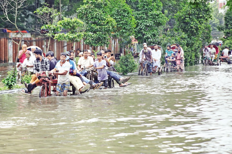
 Residents navigate waterlogged streets in Dhaka following six hours of continuous rain from midnight on Tuesday. The photo, taken in the New Market area, shows rickshaws and vans carrying passengers. — FE Photo
 Bangladesh on Wednesday experienced heavy rain that inundated large parts of Dhaka and raised the risk of flooding in several districts.
The meteorologists warned that the rain spell may persist until at least October 5.
On Wednesday, the capital experienced its heaviest rain of the year, recording 206 millimetres within 24 hours.
The deluge paralysed traffic and left many neighbourhoods waterlogged, with parts of Mirpur, Motijheel, Bijoynagar, Moghbazar, Mohammadpur, Dhanmondi and Old Dhaka submerged.
In some areas, knee-deep water accumulated, forcing pedestrians to wade through mud and stagnant water while vehicles, particularly rickshaws, struggled to move. Although the day was a government holiday, many people who ventured out for essential work were caught in severe disruptions.
"It was impossible to move in some areas. Rickshaws were getting stuck, buses were delayed, and walking was equally difficult," said a resident of Mohammadpur. Shops and small businesses in low-lying areas also reported water seeping into their premises.
Meteorological Explanation
According to the Bangladesh Meteorological Department (BMD), the rains were triggered by deep convective cloud formation rather than directly by the low-pressure system in the Bay of Bengal.
Meteorologist Bazlur Rashid explained that Bangladesh typically receives territorial rains in early October as the monsoon season winds down, often resulting in heavy showers over several days.
"Similar patterns were observed last year. The heavy rains may continue until October 4 with thunderstorms, and conditions should improve after October 5," he told The Financial Express.
The Met Office reported that a well-marked low had formed over the west-central Bay and adjoining areas, which could intensify into a depression. A trough of low pressure currently extends from East Uttar Pradesh through Bihar and West Bengal to Assam, passing across northern Bangladesh.
Monsoon activity remains active over the country and strong over the North Bay, sustaining heavy downpours.
Light to moderate rain or thunderstorms, accompanied by temporary gusty winds, are forecast for most parts of Rangpur, Rajshahi, Mymensingh, Dhaka, Khulna, Barishal, Chattogram and Sylhet divisions. Heavy to very heavy falls are likely in pockets, particularly in the western, northwestern and southern regions.
Warnings In 7 Districts
The Flood Forecasting and Warning Centre (FFWC) has issued alerts for low-lying areas of Chattogram, Feni, Lalmonirhat, Nilphamari, Sherpur, Mymensingh and Netrokona districts, reports bdnews24.com.
Officials said that continued rainfall, coupled with rising river levels, could trigger short-term flooding in these areas.
"The Muhuri and Selonia rivers in Feni may flow above danger levels in the next three days, inundating nearby low-lying areas," said Md Mahmudul Islam Shovon, assistant engineer at the FFWC.
The Feni River itself may rise to warning levels in Chattogram district, while water levels in the Gomti, Selonia and Muhuri rivers have already increased in the last 24 hours.
In the north, water levels of the Dharla and Dudhkumar rivers in Rangpur Division have dropped slightly, while the Teesta remains stable. However, forecasters warned that the Teesta could rise again, potentially inundating parts of Lalmonirhat and Nilphamari.
Meanwhile, the Kangsha River in Mymensingh has fallen slightly, but levels of the Someshwari and Bhugai-Kangsha rivers may rise to warning thresholds, leading to flooding in Sherpur, Mymensingh and Netrokona.
Higher-than-normal tides have also been observed in coastal rivers in Barishal, Khulna and Chattogram divisions, which could persist for several days.
Coastal Warnings
Given the system's movement, seaports in Chattogram, Cox's Bazar, Mongla and Payra have been instructed to hoist local cautionary signal No. 3.
Gusty and squally winds are expected in the North Bay and adjacent coastal regions as the low-pressure system intensifies further and likely moves towards the coasts of South Odisha and North Andhra Pradesh in India within the next 48 hours.
Climate Change Impact
Meteorologists noted that climate change is increasingly disrupting Bangladesh's seasonal cycles.
"Unlike last year, winter is unlikely to arrive early this time," Mr Rashid said. "We may see temperatures fall slightly after mid-October, but true winter will likely arrive in November in the northern parts of the country and take longer to reach Dhaka."
Citing recent research, he added that global warming has prolonged summers while shortening winters, disrupting traditional agricultural and environmental rhythms.
Experts also highlighted that Dhaka's worsening waterlogging is a result not only of extreme rainfall but also of unplanned urban growth. Rapid industrialisation, reduced greenery, shrinking wetlands and the destruction of natural canals have left the city more vulnerable.
The loss of water bodies has undermined the drainage system, preventing rainwater from flowing to lowlands and prolonging stagnation.
"The waterlogging we see is as much a man-made problem as it is a natural one," said an urban planner. "Unless we restore wetlands and improve drainage, Dhaka will continue to face severe disruptions whenever heavy rains hit."
Both the BMD and the FFWC predict that the heavy rainfall may persist until October 4, with gradual easing expected from October 5. Authorities remain on high alert for flash floods in vulnerable districts and have advised local administrations to prepare for temporary inundation.
nsrafsanju@gmail.com
© 2026 - All Rights with The Financial Express