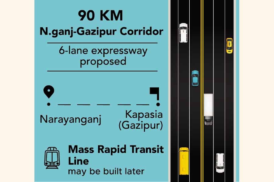
90km N'ganj-Gazipur corridor on the cards
Study proposes six-lane highway with bus, train-based services
MUNIMA SULTANA | Sunday, 6 December 2020
A feasibility study has proposed building a national highway in the city's eastern fringe area, keeping the scope for both bus and train-based mass transit services due to a faster growth in the number of inhabitants in new townships.
The feasibility study on the Bus Rapid Transit Line 7 (BRT 7) has recommended developing the 90-kilometre corridor in the north-south direction from Narayanganj to Kapasia for having the scope of ridership for 80,000 passengers per hour per direction (PPHPD) within next 15-20 years.
The draft final report, submitted to the Dhaka Transport Coordination Authority (DTCA) recently, proposed developing the corridor as a six-lane expressway with the facility of BRT along with 14 interchanges in next 10 years.
The report has also proposed building a mass rapid transit (MRT) line with the development of the area in future.
DTCA officials said the corridor would be an important primary road in north-south direction in parallel to the existing lone and saturated north-south highway that crosses through Hazrat Shahjalal International Airport road and Dhaka-Joydevpur road towards Mymensingh.
For development of the new corridor, they said, immediate measures are needed to recover grabbed land at some points of the right of way (RoW).
DTCA Traffic Engineer Mohammad Anisur Rahman said the highway would establish direct connection between Narayanganj port city and Gazipur.
After finalization of the report in December, he said, it will be sent to the Ministry of Road Transport and Bridges for necessary actions.
The traffic engineer also said immediate measures are needed to develop the corridor and protect the area from encroachment as this corridor has potential to be a straight primary road with better integration between east-west direction roads through interchanges.
Stressing the need for primary road studies under the BRT project, Professor Mohammad Shamsul Hoque said it is very important to protect the right of way (RoW) of all the alignments recommended in the strategic transport plan (STP) to implement on a priority basis in the eastern and western fringes for ensuring healthy expansion of Dhaka with solution of traffic jam.
He said the government must declare the RoW of these roads including BRT-7 to save them from encroachment as well as guide all concerned to take up right projects in time.
The DTCA has taken the move to conduct the feasibility study on BRT-7 alignment recommended in the revised Strategic Transport Plan (RSTP) in 2015 running through Dhaka's eastern fringes. It was estimated at 60 km from Narayanganj to Gazipur.
But the study recommended extending the corridor up to Kapasia to connect it with the planned economic zone north-west of Kapasia.
The study found that against the planned 272-foot road shown in the Detailed Area Plan (DAP) from Signboard to Demra, only 170 feet were available at many points because of illegal establishments.
Besides, the road crossing from Balu river to city bypass has also been narrowed to 170 feet due to development of plots for housing projects. There is also lack of roads in some parts of the corridor.
Although previous master plans -- DAP prepared during 2010-2015 and Dhaka Metropolitan Development Plan (DMDP) 1995 and Strategic Transport Plan (STP) 2005 -- have proposed a comprehensive road network in the eastern fringe, the study found that in practice, very few of the proposals were implemented keeping the actual width of the road.
As the road from Narayanganj link road to Dhaka-Chattogram highway has been built, the study recommended developing the road as an expressway in the first phase by 2023. The BRT can be introduced on this route.
The study recommended constructing the road from Signboard to Purbachal by 2025, Purbachal to Tongi and Gazipur by 2027 and Gazipur to Kapasia and Rajendrapur by 2030.
The study proposed building the new MRT line-7 by 2040 considering rapid development of the area.
According to the study, the RoW will require at least 118 feet or 35 metres for six-lane expressway, BRT-7 lanes and future MRT, but it would need more land for side roads on both sides of the expressway, collector roads and also for side slopes and junctions and interchanges.
But the study found challenges in interchange design as it recommended developing 14 highway interchanges and 10 transit interchanges with the facilities like three-level stacked roundabout, and elevated U-loops for ensuring uninterrupted traffic.
smunima@yahoo.com