Causes of floods in Eastern BD and way forward
Helal Uddin Ahmed | Tuesday, 3 September 2024
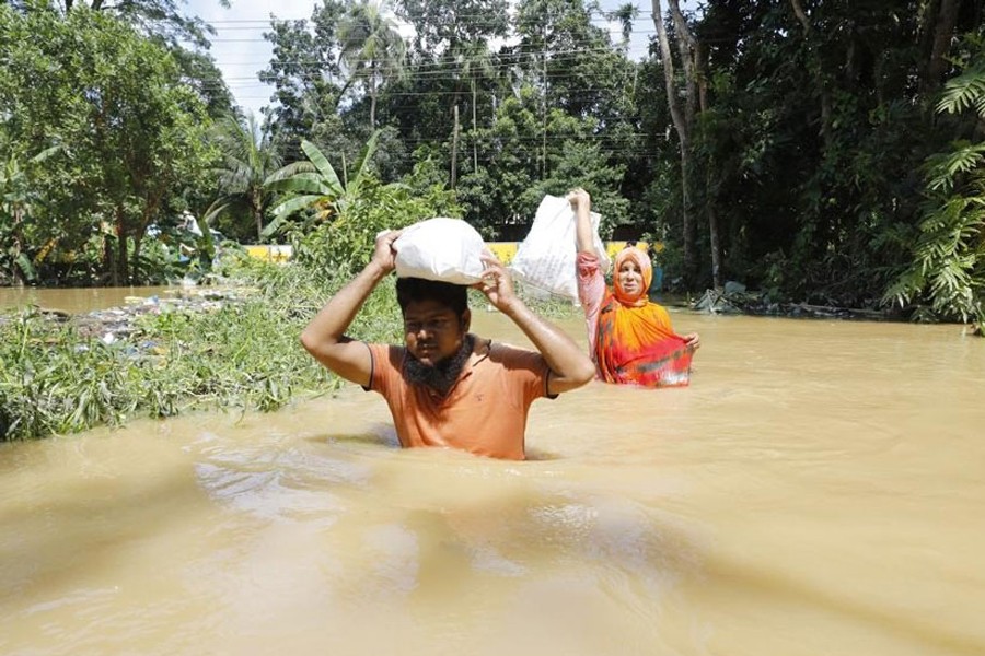
People in the eastern region of Bangladesh, especially in mid-southeast, have not witnessed such a terrifying flood as seen in the second half of August this year, ever since the country's independence in 1971. Consequently, due to the unexpected nature of the event, the people in this region suffered a lot more than in other regions of the country, where floods are a recurring phenomenon every year. It is therefore crucial to understand and pinpoint the causes and ramifications of this sudden flash-flood in order to decide on the remedial measures and future courses of action in the coming years.
The first and foremost cause of this flash-flood is related to the topographical features of the region, as well as trans-boundary rivers flowing from India to Bangladesh. Lying on the mid north-eastern side of Bangladesh, the Tripura state of India is basically a hilly terrain, where hills rise up to a height of 3 thousand feet. Seven districts of Bangladesh - Moulvibazar, Habiganj, Brahmanbaria, Cumilla, Feni, Chattogram, and Khagrachhari - share the border with Tripura. A number of rivers enter Bangladesh after emerging from the hills of Tripura, and of the 54 recognised trans-boundary rivers (actual number is over 200) flowing into Bangladesh from India, 15 flow through the Tripura state. These are: Juri, Monu, Dhalai, Langla, Khowai, Sutang, Sonai, Haora, Bijani, Salda, Gomati, Dakatia, Silonia, Muhuri, and Feni. Among these, six flow towards the north, six to the west, and the remaining three towards the south after entering Bangladesh. It implies that the rain-water can swiftly enter Bangladesh from Tripura in no time through these rivers. And when the rain is excessive within a short period of time, then it takes the shape of flash-flood wreaking havoc in the affected areas.
Apart from Tripura, flow of river-water from the hilly Meghalaya state of India on the northern side of Sylhet-Sunamganj region also creates flash-flood in the wake of heavy downpours, as was witnessed during May-June this year. However, through whichever border point it may enter, the water that flows into Bangladesh from India is ultimately carried by the country's major rivers before being flushed out into the Bay of Bengal. The severity of floods increases when the water enters the bay slowly owing to excessive tide during full-moon (Purnima) and new-moon (Aumabasya) episodes of the lunar cycle.
Monsoon in the Tripura state of India lasts from May to September each year. The annual average rainfall in the state is slightly higher than Bangladesh. However, this average rainfall is less compared to that of the Meghalaya state. But according to available information, clouds started to explode in the Tripura state and bordering areas of Bangladesh from August 19 this year due to weather condition. Besides, cooler air from the western direction was also entering the eastern skies that exacerbated the situation.
On the other hand, the low pressure from the Bay of Bengal reached Feni, Noakhali, and Cumilla districts via Cox's Bazar and Chattogram at the same time. The monsoon wind also became very strong simultaneously. Due to the combined effect of these three climatic causes, the clouds were accumulating in thick layerson the sky over the whole region. At one juncture, it gave rise to heavy downpours when it burstout or exploded in the sky, and tides of water arriving from Tripura wreaked havoc in Bangladesh territories through flash-flood. In fact, the area covered by this catastrophe extended from Tripura up to over 50 to 70 kilometres inside Cumilla and Feni districts.
Within a span of four days from 19 to 22 August, there was 435 millimetres of rain in Feni alone. In Cumilla, the amount of rain during the same period stood at 557 millimetres, and in Noakhali it was 605 millimetres, which were much higher than normal. At the same time, there were 375 millimetres of rain in Southern Tripura district of India, 350 millimetres of rain in Gomati district, and 180 millimetres in Agartala and Edinagar. These quantities were much higher than normal rainfalls in August, and resulted in the worst floods Tripura state has witnessedin three decades.
It is quite obvious from the above-mentioned facts and figures that the devastating floods inthe Bangladeshi districts bordering Tripura (Feni, Cumilla, Brahmanbaria, Khagrachhari, Habiganj, and Moulvibazar) were caused by excessive water-flow from the hills of Tripura, which was reinforced by continuous heavy downpours in those districts. At the same time, high tides were observed in the Bay of Bengal due to full-moon on the night of August 19, which increased the severity and duration of floods in the Noakhali and Lakshmipur districts, as it restrained and delayed the flood-water of downstream districts from gushing into the sea.
The release of water from the upstream Dumbur dam of India also had a role in the worsening of flood situation in Bangladesh. As mentioned earlier, Gomati is one of the 15 rivers that enter Bangladesh from Tripura. It emerges from the Dumbur Lake on the north of Khagrachhari border and enters Cumilla district after flowing 120 kilometres through Tripura. After entering Bangladesh, this river flows across the northern side of Cumilla town, then rumbles through the Burichang upazila, and finally merges with the Meghna River after crossing Muradnagar, Gouripur, and Daudkandi.
The Indian government had constructed the Dumbur hydroelectric dam in 1976, some three kilometres downstream from the Dumbur Lake. It is comparatively smaller than the Kaptai Dam of Bangladesh. The height of this dam is 30 metres, production capacity is 15 megawatts, and the number of emergency gates (spillways) is three. In contrast, the Kaptai Dam has a height of 45 metres, its production capacity is 230 megawatts, and the number of emergency gates is 16. When the water level in the dam crosses the designated height, it needs to be released by opening the emergency gates. In some dams, this gate opens up automatically due to water pressure. If the excess water is not releasedby keeping the gates shutwhen the dam gets filled up, then the dam may break up and water in the reservoir may cause massive destructions by flowing downstream at ferocious speed. Therefore, releasing the extra water through emergency gates after the reservoir is full with wateris a normal procedure.
Let us now deal with the effect of the opening of two emergency gates at Dumbur Dam on the recent floods in Bangladesh. The Indian authorities have claimed that the maximum holding capacity of the Dumbur Dam is 94 metres. When the water level in the dam crossed the designated limit, the two emergency gates opened up automatically and the released water had to cross 120 kilometres across Tripura before reaching Bangladesh. There has also been a counter-claim that the two emergency gates were in fact deliberately opened by the authorities. Whatever the truth, this excess water released from the dam entered Bangladesh after flooding the Gomati River and its surrounding areas. Besides, apart from the river Gomati, water from the remaining 14 trans-boundary rivers also gushed towards Bangladesh territory at tremendous speed from the hilly terrains of Tripura. Feni district was most severely affected by this flood owing to the water flowing through the Muhuri and Feni rivers.
In the past, some agreements were signed by Bangladesh and India on sharing information about the water-levels of some trans-boundary rivers, which is used for water modelling and flood forecasting in this country. But it has been found that India did not inform Bangladesh about the opening of emergency gates at Dumbur Dam, although they should have done so as an upstream country under the provisions of relevant international agreements.
In fact, India has been unilaterally withdrawing water during the lean season by constructing numerous dams and barrages on trans-boundary rivers, which clearly violate international water laws. On the other hand, Bangladesh could not undertake the Ganges Barrage project at Pangsha of Rajbari for water management during the dry season, despite completion of its design, due to Indian opposition. If this barrage was constructed, then it could play a huge role in preventing salinity and desertification in the south-western region of the country by conserving the water of Padma River and then releasing those during the dry season.
The Ganges Water Sharing Treaty of 1996 mentioned that such treaties should be signed for the remaining recognised trans-boundary rivers as well. But not a single treaty has been signed since then. Although the two countries had reached agreement on the draft of a water-sharing treaty for the Teesta River back in 2011, it has not been signed yet due to domestic politics of India. As a consequence of unilateral withdrawal of Teesta waters by India through the Gajoldoba Barrage, the Teesta Barrage Irrigation Project of Bangladesh runs out of water during the dry season, resulting in severe adverse effects on underground water and environment.
Unfortunately, Bangladesh has not yet sought legal remedies against India's unilateral withdrawals from trans-boundary rivers. For example, the country is not yet a signatory to The Water Convention or 'The Convention on the Protection and Use of Transboundary Watercourses and International Lakes', which was adopted in 1992 in Helsinki and has been in force since October 1996.It was meant to serve as a mechanism to strengthen national measures and international cooperation for the ecologically sound management and protection of transboundary surface waters and groundwaters. Similarly, Bangladesh is not a signatory to the 1997 United Nations Convention on the Law of the Non-Navigational Uses of International Watercourses (New York Convention), which came into force in 2014 after Vietnam became a signatory. If India does not agree to equitable and rights-based basin management of over 200 common rivers shared by the two countries, then Bangladesh can justifiably seek remedies under these two transnational instruments.
Against the backdrop, the interim revolutionary government of Bangladesh led by the Nobel Laureate Professor Muhammad Yunus should opt for extensive water diplomacy with the neighbouring countries of South Asia including India, Bhutan, Nepal, and China. If needed, it should seek assistance from relevant international organisations including the United Nations (UN), in line with applicable international treaties, laws, and agreements on water-sharing, for establishing Bangladesh's inherent right over the waters flowing through trans-boundary rivers.
Reference: Md. Ataur Rahman, "Purbanchaleyo Bonya, Karon Ebong SamnerKaronya" in the daily Prothom Alo, August 28, 2024.
Dr Helal Uddin Ahmed is a retired Additional Secretary and former Editor of Bangladesh Quarterly.
Email: hahmed1960@gmail.com