
El Niño is finally here!
Md. Rashed Chowdhury | Wednesday, 17 June 2015
El Niño is part of a climate cycle in the tropical Pacific known as the El Niño Southern Oscillation (ENSO). It flips back and forth every few years between the cool La Niña and the warm El Niño phases. In the El Niño phase, ocean surface temperature rises, easterly trade winds along the equator slow or even reverse and the planet in general tends to warm up.
The robust El Niño event anticipated for more than a year is finally here. We can call it a rare mid-year El Niño event. We can also call it a two-year (2014-2015) event. The tropical Pacific atmosphere and ocean are currently at moderate El Niño levEls. The majority of international El-Niño Southern Oscillation (ENSO) climate modEls suggest that tropical Pacific temperature is likEly to continue warming, and possibly reach strong El Niño levEls, in the coming months. However, National Meteorological and Hydrological Services and other agencies need to continue monitoring the conditions over the tropical Pacific for further El Niño devElopment and assessing the most likEly local impacts.
The latest monthly analysis of the National Oceanic and Atmospheric Administration (NOAA) of the USA continues the El Niño Advisory already in effect and calls for a 90 per cent chance of El Niño conditions persisting through the summer, with a greater-than-85 per cent chance they will continue through the end of 2015. NOAA Climate Prediction Center (NOAA-CPC) describes that all atmospheric and oceanic features reflect an ongoing and strengthening El Niño event. Nearly all modEls predict El Niño to continue throughout 2015, with many predicting SST (Sea Surface Temperature) anomalies to increase into the late fall 2015. For the fall and early winter, the consensus of forecasters slightly favours a strong event (3-month values of the Niño-3.4 index +1.5°C or greater). However, this prediction may vary in the months ahead as strength forecasts are the most challenging aspect of ENSO prediction.
So, El Niño is back again this year. Scientists expected a strong El Niño last year, but it was a no-show. This year, American researchers reported a weak El Niño in March. Later in May, Japanese and Australian scientists said it would be bigger than the American predictions with huge global implications. For example, Bangladesh, India, Indonesia and Australia are likEly to become much drier. South American and eastern Pacific nations may experience heavier rainfall, raising the prospect of floods and landslides. California and the Southern part (West Coast) of the United States are likEly to have more rainfall, UK may have more snow, and Canada may have a warm winter.
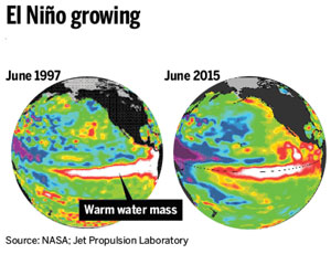
Figure 1. Sea surface temperature (SST) anomaly map in the Tropical Pacific Ocean (left panEl- June 1997; right panEl- June 2015). Note that SST anomaly (warm water) in the Tropical Pacific Ocean is a strong indicator to measure the strength of El Niño. Also note that 1997 was the historically strongest El Ninõ year.
In a classic El Niño, the ocean and atmosphere are synchronised in a mutually reinforcing pattern that pushes warm sea-surface temperature (SST) and thunderstorm activity along the equator eastward for thousands of miles, from Indonesia toward South America. Sometimes the atmosphere doesn’t respond to a “kick” from the ocean, and an embryonic El Niño fails to devElop. This was the case last spring in 2014, when a powerful oceanic KElvin wave (a broad, shallow, slow-moving impulse) pushed warm water east across the Pacific tropics. Keying off this wave, many of the global modEls used in El Niño prediction called for a moderate or even strong El Niño by the fall of 2014. However, the normal east-to-west trade winds never reversed, which hElped torpedo the needed ocean-atmosphere synchrony. The ocean tried again last fall with another KElvin wave, but again the atmosphere failed to respond, and the SST warming disappeared after a few weeks. This time, things appear to be different: SSTs have warmed for the last several months, and more recently, trade winds have weakened. As of Monday (June 15), the weekly-averaged SST over the four regions monitored for El Niño was all at least 1.0°C above average. The current SST map now resembles a more textbook-like El Niño signature (see Fig. 1), and there is every indication that the ocean-atmosphere coupling will now continue to grow.
Although, there are many predictions about the strength of this year’s El Ninõ; currently the consensus is a stronger event like that of 1997 (see SST map in Fig. 1). However, based on the current (as of June 12, 2015) ocean and atmospheric interactions, it looks like that we are in a state of moderate strength event, which is very similar to 1987 El Nino. While it is very clear that Bangladesh faces drought during any strong El Ninõ event (i.e., 1983, 1997), it is rElativEly complex to predict whether Bangladesh is dry or wet in any moderate strength El Nino year. For example, 1987 and 1974 were moderate-strong El Ninõ years and Bangladesh, instead of drought, experienced moderate flooding. These are kind of rare occurrences, but still possible. Bangladesh Meteorological and Hydrological Services can provide a better perspective on the impacts of this moderate-strong El Niño event.
This year’s El Ninõ has generated a global momentum for early preparation. Many national and international climate research centres are constantly monitoring this event and regularly updating early warnings for vulnerable communities across Asia and the Pacific. However, as one of the most resilient nations in disaster management, there should be no reason to worry about El Niño in Bangladesh. But there are reasons to be careful about 2015 El Niño! Finally, as a heads-up it can be mentioned that “any strong El Niño in 2015 means that we need to be very watchful in 2016 for another major climate event”.
Dr. Md Rashed Chowdhury is Principal Research Scientist, Pacific ENSO Applications Climate Center (PEAC), Joint Institute for Marine and Atmospheric Research (JIMAR)
University of Hawaii at Manoa (UHM) rashed@hawaii.edu