TO STREAMLINE EXCAVATION, RESTORATION
Govt moves to create digital database of 30,000 canals
PC recently approved Tk 315.70m project
JAHIDUL ISLAM | Monday, 2 March 2026
The government has moved to create a comprehensive digital database to identify around 30,000 canals -- both functional and derelict -- across the country, while assigning institutional ownership based on canal size to bring discipline on excavation, restoration and maintenance activities.
The initiative is expected to help recover encroached canals and streamline dredging of silted-up waterways, a key electoral pledge of the incumbent government, officials at the Planning Commission said.
To this end, the Commission has approved a technical project titled "Identification and Classification of Canals of Bangladesh and Preparation of a Geo-Informatics Database" and issued a government order (GO) late last week.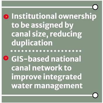 Proposed by the Ministry of Water Resources, the project -- estimated to cost Tk 315.70 million -- will be implemented by the Bangladesh Water Development Board, with implementation support from the Agriculture, Water Resources and Rural Institutions Division of the Planning Commission.
Officials of the water resources ministry said the project aims to develop an integrated GIS-based national canal network to ensure more efficient water resources management.
Under the initiative, the origin, outfall, flow pattern, basin and sub-basin areas of all canals will be identified in line with the Integrated Water Resources Management (IWRM) framework.
The project will also set standards for canal definitions and naming conventions, classify canals according to their roles in flood control, water retention, drainage and irrigation, and develop a modern, technology-driven information system for future data analysis.
Information on rural road infrastructure built over canals, including culverts and bridges, will also be incorporated into the database.
Md Mahmudul Hossain Khan, secretary to the government who recently joined the Agriculture, Water Resources and Rural Institutions Division of the Planning Commission as a member, could not provide specific details of the project.
However, Dr Md Mostafizur Rahman, the then member who chaired the Project Evaluation Committee (PEC) meeting and has recently gone on post-retirement leave, said the project would identify and list all "living and dead" canals nationwide.
The canals would subsequently be categorised into three groups -- large, medium and small -- based on size.
"At present, the Bangladesh Water Development Board (BWDB), Local Government Engineering Department (LGED), Bangladesh Agricultural Development Corporation (BADC), Barind Multipurpose Development Authority (BMDA) and other government agencies excavate canals discretely, and in many cases more than one agency works on the same canal," he said.
"To avoid such duplication, institutional responsibilities will be clearly defined and coordination strengthened."
Sources said that on February 18, shortly after the new government assumed office, the Irrigation Wing of the Planning Commission sent a letter requesting information, databases or booklets on canals excavated so far under three ministries or divisions and four agencies.
The letter, signed by SM Shafiqul Islam, deputy chief of the wing, noted that inland canal excavation and maintenance activities in Bangladesh are currently carried out by BWDB, BADC, BMDA and LGED.
Officials said the move was aimed at improving coordination in canal excavation and maintenance.
Bangladesh -- formed by sediment deposits of the Ganges-Brahmaputra-Meghna basin and recognised as the world's largest delta -- has more than 30,000 canals, according to the project proposal.
However, it noted the absence of a definitive inventory, classification or institutional framework assigning responsibility for their excavation and maintenance.
Officials said many canals recorded in cadastral survey (CS) and revisional survey (RS) land records have either been filled up or encroached upon and no longer exist on the ground.
Under the project, CS/RS maps at upazila and district levels will be used to delineate canal networks, alongside consultations with local stakeholders.
Of the total project cost, Tk 295.3 million has been allocated for local consultancy services and Tk 10.2 million for individual consultants.
The project document also noted that under an earlier initiative titled "Updating Information of Rivers of Bangladesh and ICT-based Management," data on the country's flowing rivers were updated and an online platform and mobile application were developed.
The new canal database will be integrated with the existing river database to strengthen integrated water management.
In its election manifesto, the BNP pledged to excavate and re-excavate 20,000 kilometres of rivers and canals to bolster environmental protection and climate resilience, alongside reviving the Barind project to support agricultural development.
While announcing the manifesto, party chairman and incumbent Prime Minister Tarique Rahman said the initiative would revive the "voluntary canal excavation programme" introduced by former president Ziaur Rahman.
The programme, he said, would help restore the country's 520 lost rivers and thousands of canals, revive natural water flows and improve irrigation efficiency.
jahid.rn@gmail.com