Making land market more efficient
G.M. Khurshid Alam | Saturday, 7 February 2015
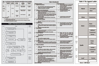
Land survey is an important ingredient in the updating of land records. The survey, which leads to settlement, is seen as a temporary process where only certain parts of the country are covered at particular points of time. Table 3 shows time span of a typical land survey along with administrative responsibility and completion rate at each stage. It could take 15 years to complete survey in one part of the country.
The steps involved in the process are listed in Table 4. A very important regulatory process is the preparation of khatian (record of rights) - the form giving plot numbers —, the khatian number, classification of land (that affects land revenue), area, crops grown, name of owner, agricultural practices along with a mouza map. This is done through periodic cadastral surveys.
As evident from Table 4, a cadastral survey done by Directorate of Land Records and Surveys (DLRS) could take 15 years to finish, and by the time it gets completed lot of the land features may change, especially in riverine areas and major urban centres where frequent changes of ownership take place.
The time required in each step of the survey at a particular location is shown in Table 4. The cadastral survey starts with creating the initial maps by very low-paid, low-level temporary employee, the Amin.
Tables 4 and 5 show the regulatory challenges affecting land governance. It is difficult for any average citizen to fully understand and navigate through this maze. He has to depend on informal intermediaries. This provides scopes for producing fake documents. Table 4 also highlights the institutional and governance challenges facing the critical survey part of land administration. For example, the Amin has to depend on boarding and lodging with some influential people in the village which carries the high risk of compromising the authenticity of maps and draft of the khatians.
The survey process and the appeal process are also lengthy. The survey process itself could take anywhere between six months to two years, depending on whether a re-survey is ordered. There is definitely scope for improvement here if necessary regulatory steps are taken and institutional changes are brought, backed by use of technology. Similarly the scope for reducing time for making appeal and steps needs to be looked into.
There is a process for review and rectification but the appeal process could take a long time and it is also costly. Where a decision relating to the recording of land title is disputed, the appeal process starts at the lowest rung of the ladder represented in Table 5 and then moves progressively upwards until the appellants and other interested parties either accept the judgment given or lack resources to proceed further.
One factor that is apparent is that the links between the three key institutions, the Survey, the AC Land, and the Sub-Registrar's office, are very weak as accountability mechanisms only moves vertically in each of the institutions, though for a efficient and transparent system there needs to be well synchronised linkages across the three institutions.
The issue gets further complicated as two of the agencies report to the Ministry of Land and the Registry is within the jurisdiction of MOLJ. So there has also to be good synchronisation between the two Ministries.
In the short and medium term, the regulatory and institutional challenge will be in bridging these gaps across the institutions as well as bringing efficiency within each agency. It will be particularly important to reduce time for undertaking surveys, simplifying the appeal process, reducing the number of days in the registration process, and finally, coming up with a more dependable and readily available certificate of title that is protected from abuse.
CONCLUSION: Bangladesh has undertaken different land-related reforms that have been supported by laws and regulations. All the desired goals however could not be achieved because the vested interest groups have always been able to exploit legislative and regulatory loopholes and institutional under-capacity. On the institutional front, efforts were made to bring in change; for example, there was the "Muyeed Committee Report" that recommended that functions of Land Registration (sub-registrar) and Record (tehsil) be brought together in a single office at field level, but it was never implemented. However, some of the difficulties could be overcome if proper computerisation was completed. The time for cadastral survey is also unduly long though new technologies are now easily available for completing this task efficiently and in shorter time.
There is an ongoing effort of computerisation of some of the processes in each of the three institutions (agencies), but it does not appear coordinated but rather on the individual Ministry basis. This needs to be a priority goal for the government, and a single strategy for implementation of all land related computerisation should be undertaken. Effective and well-coordinated computerisation of each of the agencies under the two Ministries should be able to bridge the existing gaps and provide more readily available reliable information to the citizen, business, financial institutions, and to the courts. This definitely will help improve business environment in the country while also reducing scope of corruption at different levels.
For the short and medium term:
l Computerisation of the processes and use of technology in AC Land, the sub-registrar's office, and the land survey under the e-Government programme should be of highest priority. The target should be accessibility of information to the citizen, reducing unnecessary steps. However, it needs to be ensured that there is clear links between the different agencies so that desired results can be obtained.
l The National Land Use Policy needs to be revisited, and if required a new policy that will be applicable across the MOL and MOLJ along with other Ministries (Urban, roads, water etc.) should be adopted. Of particular importance will be to ensure effective across institutions communications and that also should be where most of the information could get automatically updated limiting human interaction between officials of institutions and the citizens. The Land Use Policy should explicitly recognize that competing demand of food security and the need for creating jobs and providing housing, infrastructure.
The Government has enacted the Economic Zones Act to facilitate use of land for industry and services. However, a more articulated policy is required which would lead to zoning of the entire country so that the land use gets distributed optimally to meet the competing and sometimes complementary needs. In this context it needs to factor in other related laws like Special Economic Zones Act.
For the longer haul:
l There needs to be a full mapping of the country to determine which land will be exclusively kept for agriculture and which for industry, housing, roads and there should proper zoning laws with institutional enforcement in place. Even Government's future infrastructure and urban related investments should be built in a way that it caters to desired zoning needs of the country.
l Undertake a comprehensive public sector reform involving Ministries/ Institutions involved in land governance.
This longer term action will only be successful if the short and medium term actions mentioned above are implemented. These should help in evolving a regulatory and institutional framework that could make the land market more efficient.
Dr. G.M. Khurshid Alam is Operations Director of the
Policy Research Institute
of Bangladesh (PRI).
gmkalam@gmail.com