Of maritime boundary: The battle of the Bay of Bengal
Abdul Mannan | Saturday, 25 October 2014
The UN Permanent Court of Arbitration (UN-PCA) has recently given its judgment on the maritime boundary delimitation dispute between India and Bangladesh. The award is final having no recourse to appeal. However, it has left some special issues for future amicable settlement either by the parties concerned or through the good offices of the UN.
Let me take the advantage of a term 'Opportunity Cost' or 'Opportunity lost' often used in management accounting. According to the book titled The Principles and Practice of Management, edited by E.F.L. Brech, "The Opportunity Cost' by this title is meant the cost of a lost opportunity, rather than the actual cost incurred...This notion is called opportunity Costing."
This principle of opportunity cost or opportunity lost will be taken into account in this write-up so that we are placed on a better footing to analyse the 'Cost-benefit ratio' or 'gain or loss' in proper perspective.
The impacts of the disputed scenario of delimitation are as under:
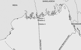
(i) Bangladesh asked for drawing the delimitation line at 180 degree based perhaps on the equity which earmarked an area of 25602 sq km of the sea area as against India's insistence at 162 degree on the basis of equidistance which would have left nothing out of the 25602 sq km for Bangladesh as claimed by it.
The UN-PCA judgment on the basis of equity the delimitation has been contemplated at 177.50 degree that has allowed only 19467 sq km sea area (territorial water) in favour of Bangladesh leaving an area of 6135 sq km in favour of India. Incidentally, this area of 6135 sq km encompasses, inter alia, South Talpatty.
Whereas India's argument to draw the delimitation line at 162 degree was reportedly based on the equidistance concept and Bangladesh's proposed line at 180 degree was perhaps based on the equity and that by UN-PCA at 177.50 degree was also based on the equity, it is not clear as to where and why does the concept of the equity methodologies differ? We have points to ponder.
(ii) As for the exclusive economic zone of 200 n.m. and the continental shelf up to the high sea, the UN-PCA more or less, we have been given to understand, agreed to Bangladesh's claim in awarding it undeniable sovereign rights.
(iii) With regard to hydrocarbon exploration of 28 blocks, India raised dispute on 10 blocks and Myanmar on 17 blocks respectively. Bangladesh meanwhile agreed to readjust 12 blocks as settlement with Myanmar and would need now to adjust 5 blocks with India as settlement. It seems there was no other way but settle in order to avoid potential loss instead of keeping it pending for ages together, for a bird in hand is better than two in the bush.
(iv) Gray area: In the UN-PCA Award there is a gray area of 50 sq km in the delimitation as processed. The area is gray and with an apology I may also say the judgment is also gray should we consider that the water resources (fish etc.) of the gray area will belong to India and the sea bed resources (minerals and gas, etc.) will belong to Bangladesh. How will Bangladesh move its logistics without India's permission, to explore sea bed resources? The award of the UN-PCA could have given such rights to Bangladesh.
(v) South Talpatty: The Key Point Issue (KPI in different connotation) is South Talpatty. India did put claim to draw the delimitation line at 162 degree on 'equidistance' basis knowing fully to encompass South Talpatty and on similar analogy Bangladesh drew the line of delimitation on 'equity basis' at 180 degree. The intrinsic idea is quite obvious. South Talpatty did exist, then became non-existent and once more started the phase of emerging, at least the satellite image, of late, does say so (Ref : Prof Amir Hussain Bhuiyan of Jahangirnagar University and write-up by syed Mahbub Murshed). South Talpatty has now developed from its original area of meagre 350 acres to 8500 hactares and currently it shows gradually more and more stable but remains submerged under shallow water during the high tide of the sea. Prof A.H. Bhuiyan also mentions that the satellite images do also indicate that due to silt-load carried by the river Hariabhanga the island 'South Talpatty' is, by all criteria, likely to join the mainland of Bangladesh.
It is pertinent here to highlight South Talpatty in that the UN-PCA simply refused to take cognizance of a non-existent (Ref- write up of Mr. Sadeq Khan) shore-line claim by either side (India and Bangladesh) and preferred to draw the line on the basis of existing shore line. Reportedly, our Foreign Minister has said that after the cyclone in Urir Char in 1985, South Talpatty has gone under water and does no more exist. It is suicidal and sweeping statement by the Government. At least, the latest satellite images speak otherwise. How can we overlook this development? Virtually we have given in! The Government, including some high-ups in the party in power, recently spelt out that since the island does no more exist, the question of claims and counter-claims is irrelevant. It is now imperative to spell out the potential of the island, strategic values, and intrinsic values of its underlying vast resources including estimated deposit of 100 T.C.F. gas and so on.
Taking into account the above-mentioned issues, the 'opportunity cost' or the 'opportunity lost' need to be evaluated and since it is still unresolved due to non-existent status of the island as classified by the UN-PCA, South Talpatty issue may be raised at UN by an appeal for consideration in future at an appropriate time. Let the 'opportunity lost' not go unnoticed.
The writer is a former State Minister, Civil Aviation & Tourism and Textiles and
Past President, South
Asian Federation of Accountants (SAFA).
abdul.mannan@bengal-airlift.com