Disputes over reclaimed river-eroded land--often deteriorating into blood feuds--are destined to drown as ownership is being determined through digital mapping.
Officials say the government is set to draw Alluvion and Diluvian Line ( AD Line ) by applying state-of- the -art technology aiming to ensure sustainable river training and proper land -management system in the country.
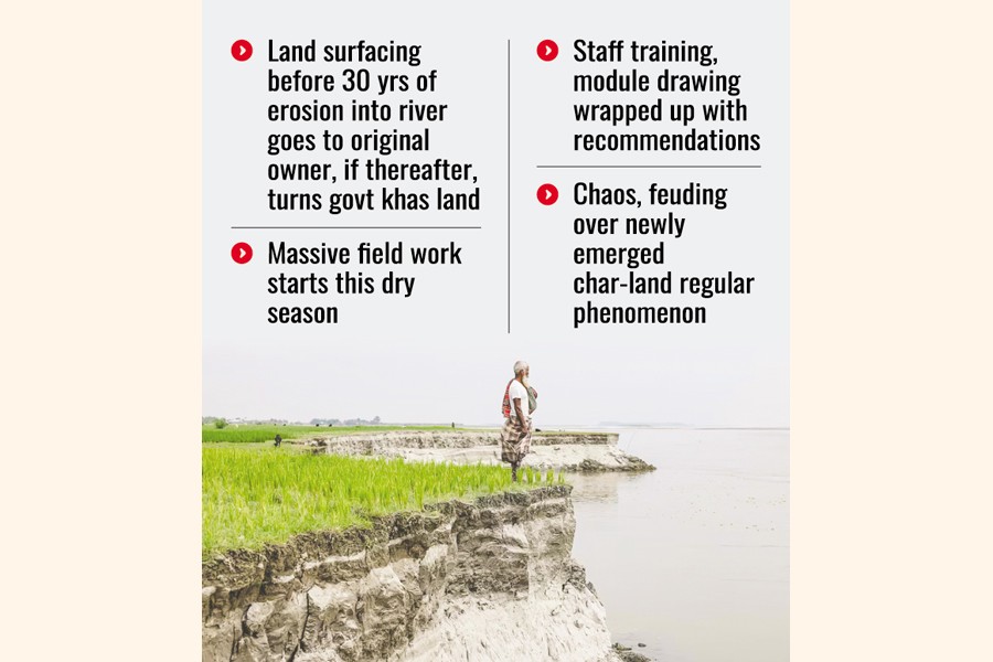
Chaos and violence have become a regular phenomenon regarding land ownership on chars that emerge out of rivers due to the absence of regular work of AD Line for determining rivers and adjoining lands under private ownership.
Bangladesh follows The Bengal Alluvion and Diluvian Regulation 1825, The Alluvion Land Act 1920, The State Acquisition and Tenancy Act 1950 ( section 86 and 87) for drawing AD Line, and The Survey Act 1875, Land Management Manual 1990, The Non- Agricultural Khas Land Management and Settlement Policy 1995, The Agricultural Khas Land Management and Settlement Policy 1997, Land Development Ordinance 1976 and Bengal Tenancy Rules 1955 for land management.
Bangladesh is a riverine country and river erosion is a common phenomenon.
Due to river erosion ( Diluvian) the owners of the lands lost their lands.
At the same time, due to appearance of new char lands (alluvion) on the rivers, complications arise over settling the ownership of the land--whether it was government-owned (river land) or personal.
As part of the move, the Ministry of Land (MoL) has taken initiative to draw AD Line regularly by applying new modules and training aiming to determine land boundary and also the real ownership of the land devoured by the river.
A high official at the Ministry of Land told The Financial Express that they were seriously working to draw AD Line regularly to forestall such disputes.
It becomes a common trend in the country that a dispute will arise when new char land emerges ( alluvion) on the river and most of the time create difficulties in managing river land properly, depriving the government of realising revenue, he points out.
"Drawing AD Line regularly will certainly help keep RoR ( right of record of land ownership) properly, helping to realise land revenue regularly, reducing intention of filing litigation for ownership of land, either government or public -following alluvion and diluvian," says the official.
"Proper management of alluvion land not only helps increase food production and food security but also gives a strong footing for proper land-management system."
For drawing a proper, scientific, state -of- the art and sustainable AD Line, the government is considering giving training to the Additional Deputy Commissioners ( ADCs- Revenue), Assistant Commissioners ( AC Land), Kanungos and especially surveyors and officials at the union land offices.
The land ministry official says that they recently organised a workshop on AD Line for surveyors so that they could survey river boundaries properly.
The officials concerned of the MoL, ADCs ( Revenue), Kanungos and Surveyors at the workshop discussed extensively the dos about AD Line.
The participants dividing into separate groups at the workshop placed their respective recommendations on the proposed module and curriculum for providing training on AD Line initially for surveyors.
They also stressed revisiting and bringing a time befitting amendment of The Alluvion Land Act 1920.
The role of ADCs (Revenue) in maintaining the latest land records and the Department of Land Survey is highly critical.
The proposed module/ recommendations are : concept analysis of Alluvion and Diluvian Line, introduction of modern and technical instruments, determination of areas through using GIS software and drone napping, determining the flow of river, incorporating a provision in the law so that the land owners affected owing to river erosion could get financial compensation like the process of land acquisition, giving five days' practical training to the surveyors, including at least one day, at the field level.
River Morphology and Seasonal Behaviours, legal and surveying framework, alluvion indicators on maps, diluvian indicators on map, tools and resources for line determination, satellite images by Google Earth, Landsat, GPS system, total station data, cadastral sheets, geo-referenced maps, field sketches and criss sections, multi-tear satellite interpretation, how to draw the Alluvion Line, how to draw the Diluvian Line, marking deposition- boundary points, connecting points following natural river contour, field-survey techniques, drawing on paper maps, drawing on using GIS software, GPS coordinate collection, criss- section observation, analysing given satellite images, identifying deposition and erosion areas, drawing both lines digitally and preparing final map were also among the issues discussed.
Director of Land Administration Training Centre (LATC) Mohammad Abul Khayer told the FE that the MoL would prepare a draft module on training AD Line for land officials especially and initially for surveyors.
"At least two weeks are needed for providing state-of- the-art training to the surveyors, with an additional three days for gathering practical knowledge at the field level," he said.
Out of 64 districts in the country, many rivers are flowing through different districts, causing river erosion at regular pace.
Lalmonirhat, Kurigram, Bogura, Rajshahi, Chandpur, Munshiganj, Shariatpur, Pirojpur, Patuakhali, Manikganj, Noakhali, Laximpur, Bhola and Barishal are among the districts that perennially witness river erosion.
He notes that if a new char emerges on the riverbed after 30 years, then that land will be treated as a government property. If the land emerges before 30 years, it could be a personal property provided with adequate proofs.
Mr Khayer says they will soon send recommendations on the draft training module and curriculum, for surveyors and other concerned land ministry officials, to the MoL for getting approval.
And the training programme will be started, initially for surveyors, after land ministry's approval and find fund allocation and disbursement.
Asked when the training will start, he said that they would start the programme during the present dry season.
He hopes if AD Line is drawn properly by using modern technology, "it will stop significantly land- related litigation and violence that deal huge financial losses".
Senior secretary at the MoL ASM Saleh Ahmed told the FE that AD Line is a very important and sensitive issue in Bangladesh.
"Considering the riverine reality of Bangladesh, giving proper, intensive and state-of- the-art training on AD Line to the land officials will act as a solid base for good governance in land management, including determining the real ownership of land," he says.
"It will also safeguard revenue collection and help augment food production and security."
talhabinhabib@yahoo.com
© 2026 - All Rights with The Financial Express