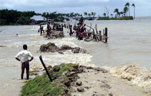
 Ten villages in Nazirpur area and, five villages in Charipara area under Kalapara upazila of Patuakhali district got flooded following collapse of the flood control dykes in the areas due to strong tidal surge under the impact of full moon.
 As reported by the media, swelling rivers in the country's north inundated fresh areas, and flood was heading for Dhaka. According to the Water Development Board (WDB), the Brahmaputra, Jamuna, Kangsha, Surma, Dhaleswari and Lakhya flowed above danger level in at least 10 points on the day (as of August 22, 2014). Downpours, mostly in the bordering Indian hills, cause this rise in water level in the Brahmaputra and Jamuna basins.
It is surprising to see how an expected strong El Nino event has been changed to a moderate one and flooded Bangladesh. It happened once or twice before with minor flooding, but the event of 1987 is the most significant one when Bangladesh was severely flooded during a moderate El Niño year. Actually, Bangladesh is supposed to be drier than normal (less than normal flooding) during any El Niño year. I agree that downpours mostly in bordering Indian Hills are the primary causes of flooding in Bangladesh. Rainfall inside Bangladesh didn't contribute much to this flooding. However, my curiosity is why there is so heavy downpour in the upstream of the greater Ganges-Brahmaputra-Meghna (GBM) region in India when this area is also supposed to be drier than normal during a moderate El Niño year (Indian news media also reported a dry season this year). So, this year's El Nino appears to be a peculiar event with some unexpected impacts. However, one probable reason for this heavy downpour could be the enhanced cyclonic activities in the ocean, which we normally observe in any El Nino year. Today, my objective is to provide an improved description of the El Niño/La Ninã-related drought/flooding perspectives for the greater GBM region and Bangladesh.
The readers are probably familiar with El Niño. However, in a nutshell, El Niño is a band of anomalously warm ocean water temperatures that periodically develop off the Pacific coast of South America. It normally starts to develop in summer (May-June-July), reaches its peak in the winter (October-November-December), and gradually loses its punch through the spring (April-May-June) of the next year. The strength of El Niño can be weak, moderate, or strong. From a historical perspective, weak, moderate, and strong strength El Niño years are listed below:
EL NIÑO YEARS:
Weak: 52-53, 53-54, 58-59, 69-70, 76-77, 77-78, 04-05, 06-07;
Moderate: 51-52, 63-64, 68-69, 86-87, 87-88, 91-92, 94-95, 02-03, 09-10, and 2014;
Strong: 57-58, 65-66, 72-73, 82-83, 97-98.
Previous observations in 1982/83, 1987/88, and 1997/98, revealed that Bangladesh rainfall maintains strong relation to El Niño event and indicated negative values of SOI (Southern Oscillation Index) (-0.8 or lower) are related to dry extremes (which means less rainfall and basin-wide dry condition). It has also shown strong relations with La Nina event and displayed that the positive values of SOI (+0.8 and higher) are correlated to wet condition (which means more rainfall and basin-wide flooding condition). Note that the negative values of SOI is a measure of El Niño and -0.8 or lower means strong event; similarly, SOI +0.8 or above means strong La Nina event. So far, all the major El Nino years (1951, 1958, 1972) have recorded significant rainfall deficits (- 38% in 1951, - 48% in 1958, and - 10% in 1972) and, all the major La Nina years (1964, 1973, 1988 and 1998) have recorded excessive rainfall (+4% in 1964, +8% in 1973, +30% in 1988, and +10% in 1998).
In the case of a moderate El Nino and La Nina events (SOI values are in between -0.4 to -0.8 and +0.4 to +0.8), the SOI-rainfall relations are sometimes contradictory. While the moderate La Nina year and basin-wide enhanced rainfall relation is somewhat clear, the relation appeared to be confusing during the moderate El Nino years. Therefore, climate forecast are relatively difficult in any moderate El Nino year. For example, the moderate La Nina years (1956, 1970, 1971, 1984, and 1999) always recorded excessive rainfall in Bangladesh (+1.7% in 1956, +11% in 1970, +5% in 1971, +18% in 1984, and +12% in 1999) and, while the expected pattern is rainfall deficit in any moderate El Nino years, some of the moderate El Nino years (1963, 1965, 1969, 1974, and 1987) displayed a tendency of receiving excessive rainfall (+18% in 1965, +16% in 1969, +7% in 1974, and +34% in 1987). So, while Bangladesh is always found to be wetter than normal (flooding) during the moderate La Nina years, it is not always drier than normal (dry or drought) during the moderate El Nino years.
Observations have already revealed that the El Nino of 2014 is very chaotic. It is still not fully developed and the probability of an El Niño forming during the current July-August-September season is slightly above 50 per cent, down from about 65 per cent a month ago. While the event was initially thought to be strong in this year, the current forecasts tended to show a weak-to-moderate event for the rest of the year. This is not very common. Climate Scientists are still struggling to find an answer for this peculiarity.
So, while Bangladesh was initially thought to be dry in 2014, it is wet now. At this stage, any definitive forecast is difficult; however, the wet condition may change to dry again soon. I believe that there will not be any serious flooding this year. I also expect a drier than normal January-February-March of 2015. The chance for more cyclonic activities is still there.
Finally, the 2014 El Nino year and its impacts on Bangladesh flooding maintain some consistency with the moderate El Nino event of 1987 and consequent flooding. Following 1987, the year of 1988 (which finally turned out to be a La Nina year) experienced catastrophic flooding. So, based on the current circumstances and available information, what will happen in 2015? We don't know yet, but need to be watchful!
Dr. Md Rashed Chowdhury is currently working as the Principal Research Scientist of the 'Pacific ENSO Applications Climate Center'. He is also a Graduate Faculty at the Water Resources Research Center, University
of Hawaii Manoa, USA.
rashed.uh@gmail.com
© 2026 - All Rights with The Financial Express